-
-
- What is the Green Circle?
- Can I walk my dog or other pet?
- How long is the Green Circle?
- What will I see?
- What is the most scenic portion?
- Where can I get a map?
- What are the hours?
- Where can I park?
- Where are restrooms?
- Is there water and food available along the trail?
- Is the trail wheelchair accessible? Can I use a motorized wheelchair or other power-driven mobility device?
- Are electric bicycles (e-bikes) allowed on the Green Circle?
- Are other types of electric motorized devices (like Onewheels, hoverboards, Segways, scooters, etc.) allowed on the Green Circle?
- Is there a fee to use the trail?
- Is there camping available near the trail?
- Can I rent bicycles along the Green Circle?
- Can I rent snowshoes or cross-country skis along the Green Circle?
- What is the teepee-looking structure off Business 51?
- How many people use the trail?
- Can I bike the entire trail?
- During winter, where can I cross-country ski, snowshoe, or snowbike?
- Are any trail sections plowed in the winter?
- Can I use fat bikes on the trail?
- What safety information should I know?
- What should I do if I see a limb down or other safety concern?
- What are the rules of the Green Circle?
- How can I help support the Green Circle?
- Who maintains the Green Circle?
- Can I sponsor a memorial or tribute bench along the trail?
- Can I hold an organized event on the Green Circle, such as a walk or run?
What is the Green Circle?
The Green Circle is a 27-mile recreational trail open to hiking, jogging, and biking. It is one of the few trail systems in the country to encircle an entire community. Popular among local hikers and bikers, it is a destination for visitors throughout central Wisconsin and beyond. The Green Circle was created as a result of diverse partnerships among communities, corporations, state entities, private land owners, and individuals.Can I walk my dog or other pet?
Pets are allowed on all segments of the trail, except the University Trail through Schmeeckle Reserve; an alternative route is available along North Point Drive to bypass this section. Pets are allowed in City of Stevens Point and Village of Whiting parks, but not in Village of Plover parks. Dogs must be kept on leashes no longer than 8 feet and should be managed in a way that poses no threat to other trail users or wildlife. Please clean up after your pet.How long is the Green Circle?
The total length of the official Green Circle is 27 miles. This includes all 12 sections of the hiking/biking main trail, including the Westside Loop (2.4 miles), an alternative to a portion of the River Pines segment. Without the Westside Loop, the trail is about 24.5 miles. The Green Circle connects with several trail spurs that can expand the possible routes: Hoover Road Trail Spur (4.5 miles), Heartland Trail Spur (2.6 miles), Stevens Point Sculpture Park trail (0.4 mile), and Schmeeckle Reserve trails (3.2 miles). It also connects to the Tomorrow River State Trail, a 29-mile railroad corridor trail that travels from Plover to Manawa.What will I see?
For miles, the Green Circle follows the scenic Wisconsin and Plover Rivers, which are historically significant to the lumber-making pioneer roots of the region. The trail meanders through forests, prairies, wetlands, meadows, and quiet neighborhoods, providing excellent opportunities to observe wildlife and wildflowers. The Green Circle links together several parks and natural areas: Pfiffner Pioneer, Bukolt, Zenoff, Yulga, Iverson, Plover River, and West River Parks in the City of Stevens Point; Upper Whiting Park in the Village of Whiting; Little Plover River, Worzella Pines, and Lake Pacawa Parks in the Village of Plover; and Schmeeckle Reserve on the UW-Stevens Point campus. It also travels through wooded lands owned by paper mill companies, Sentry Insurance, and private landowners.What is the most scenic portion?
Every section of the Green Circle has its own unique character. The River Pines Trail is popular for its large trees and stunning views of the Wisconsin River as it flows past islands and rocks. The Riverfront Trail travels through beautiful parks near downtown Stevens Point with spectacular sunset views. The University Trail meanders through a large number of habitats perfect for wildlife viewing including forests, prairies, streams, and wetlands. The Moses Creek Trail twists and turns over a wet forest on the Green Circle’s longest boardwalk. The Plover River Trail follows the meandering river for 3.6 miles, the longest segment without crossing roads. The Iverson Park Trail provides access to the historic park with incredible stone buildings and a beach nestled along the shore of the Plover River.Where can I get a map?
You can download a map from this website. Or pick up a free brochure when you’re in Stevens Point at the following locations: the Green Circle Trailhead or the Schmeeckle Reserve Visitor Center (2419 North Point Drive); the Stevens Point Area Convention and Visitors Bureau (340 Division Street North); the Stevens Point Parks and Recreation Department (2442 Sims Avenue); and Portage County Parks office (1903 County Road Y). Free parking and additional information also are available.What are the hours?
The trail is open from 6 a.m. to 11 p.m., except for the University Trail through Schmeeckle Reserve, which opens at sunrise and closes at sunset. The trail is not lighted, so use during daylight hours is strongly advised.Where can I park?
Numerous parking areas are available for free along the route, including along the riverfront in downtown and parks along the route in Stevens Point, Whiting, and Plover. See map for details. The Green Circle Trailhead located in Schmeeckle Reserve (2419 North Point Drive) is an ideal starting point with free parking, a free EV charging station, a bicycle repair station, all-season restrooms, a picnic shelter, and an information kiosk with Green Circle maps. The Schmeeckle Reserve Visitor Center is also open daily and staffed by UW-Stevens Point students who can answer your questions.Where are restrooms?
Public restrooms are available year-round at the Green Circle Trailhead located in Schmeeckle Reserve, 2419 North Point Drive, Stevens Point, WI 54481. From the first weekend in May through the second weekend in October, restrooms are also available from 8 a.m. to 11 p.m. at Bukolt and Pfiffner Pioneer Parks (Riverfront Trail), Iverson Park (Iverson Park Trail), and Little Plover River and Worzella Pines Parks (Hoover Road Trail). A porta potty is available seasonally at Yulga Park (Moses Creek Trail).Is there water and food available along the trail?
Drinking water is available year-round at the Green Circle Trailhead located in Schmeeckle Reserve, 2419 North Point Drive, Stevens Point, WI 54481. From the first weekend in May through the second weekend in October, water is also available at Bukolt and Pfiffner Pioneer Parks (Riverfront Trail), Zenoff Park (Brickyard Trail), Iverson Park (Iverson Park Trail), and Little Plover River and Worzella Pines Parks (Hoover Road Trail).Several restaurants can be found in downtown Stevens Point near the intersection of the Riverfront Trail and the River Pines Trail, especially along Main and Clark Streets. Several more restaurants, gas stations, and a grocery store can be found along Business 51 south of the intersection of the Brickyard Trail and University Trail. A few restaurants and gas stations are located where the Iverson Park Trail crosses Highway 66.
Is the trail wheelchair accessible? Can I use a motorized wheelchair or other power-driven mobility devices?
Wheelchairs, including power-driven wheelchairs, are allowed on all sections of the Green Circle Trail for people with mobility disabilities. However, not all sections meet ADA guidelines:- The Riverfront Trail, the Hoover Road Trail Spur, and the Heartland Trail Spur are paved with asphalt and accessible to wheelchair use.
- All other trail sections are surfaced with 8-foot wide boardwalks and hard-packed crushed granite, which is considered wheelchair accessible when dry and packed down.
- Wheelchair use is not recommended on crushed granite trails in early spring or after rainstorms, as the surface gets soft.
- A few steep hills on the Plover River Trail, the Paper Mill Trail, and the McDill Trail do not meet the grade requirements of ADA.
Other power-driven mobility devices are allowed for people who have a mobility disability if: 1) they do not exceed 42 inches in width, and 2) they are powered by an electric motor. These include mobility scooters, trishaws, and Segways. All users must obey the 12 mph speed limit.
ATVs, UTVs, and other motorized vehicles are prohibited, except for trail maintenance, repair, construction, and special events.
These guidelines apply ONLY to the official route of the Green Circle Trail. Numerous other trails and paths connect to the Green Circle, including spurs managed by other entities, which have their own rules and guidelines. Please contact the managing entity for more information.
Are electric bicycles (e-bikes) allowed on the Green Circle?
Electric bicycles (e-bikes/electric-assist bikes) are allowed on the Green Circle Trail only when used in pedal-assist mode. The use of a throttle to operate a bicycle without pedaling is not allowed. All e-bike users must observe the 12 mph speed limit. The Green Circle is designed for leisurely walking and biking, with curving trails and narrow boardwalks. Riding at faster speeds are safety hazards for both the rider and other trail users. Any electric bicycle capable of more than 30 mph is considered a motorcycle under state law, and is not allowed on the trail.Are other types of electric motorized devices (like Onewheels, hoverboards, Segways, scooters, etc.) allowed on the Green Circle?
No. Devices that are propelled by a motor and do not have functional pedals, such as Onewheels, hoverboards, mopeds, Segways, and electric scooters, are considered motorized vehicles and are not allowed on the Green Circle Trail. People who have mobility disabilities may be allowed to use these types of devices (click here for more information).Is there a fee to use the trail?
There is no fee required to use the trail. However, we strongly encourage donations to help maintain the Green Circle. Consider joining hundreds of individuals who value this terrific resource. Support trail construction and improvements, land purchases, and ongoing maintenance with an annual gift. Click here for more information about donating.Is there camping available near the trail?
The closest campground to the trail is Jordan County Park. It is located about two miles northeast of the trail along Highway 66. The campground has 22 sites with electrical hookups that are open May 1-October 31. Click here for more information about the campground.Please note that Highway 66 is not recommended for bicycling due to a high volume of traffic. If you would like to bike from Jordan Park to the trail, we recommend an alternative 2.5 mile route:
- From the campground, travel west on Jordan Road for about 1.5 miles.
- Turn south on Torun Road and travel for about a mile.
- The Green Circle crosses Torun Road near its intersection with Hampton Road.
Can I rent bicycles along the Green Circle?
The Hostel Shoppe, located at 3201 John Joanis Drive in Stevens Point, provides a wide selection of bicycles for rent. Visit https://hostelshoppe.com/pages/bicycle-rentals for more information.Can I rent snowshoes or cross-country skis along the Green Circle?
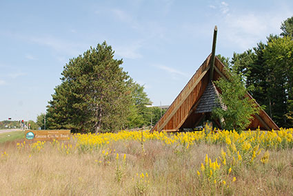
The Schmeeckle Reserve Visitor Center, headquarters of the Green Circle Trail, has snowshoes and cross-country skis available to rent. Click here for more information.What is that teepee-looking structure off Business 51?
This is a picnic shelter for the Green Circle located in a restored prairie just west of Schmeeckle Reserve. The teepee design was inspired by a structure at a historic site in western Minnesota that protected petroglyphs. It is intended to attract the attention of visitors to Stevens Point. Designed by Revelation Architects-Builders of Stevens Point, the construction supervisor, Stan Schmeeckle, is the grandson of Fred Schmeeckle, for whom Schmeeckle Reserve is named.How many people use the trail?
Over 100,000 people use the Green Circle each year, based on data gathered from several counters that are installed along the trail. According to visitor research conducted by UW-Stevens Point Forest Recreation students (2015), on average 72% of people bicycle, 17% walk, and 10% run.Can I bike the entire trail?
Yes, all 12 sections of the Green Circle are accessible to bikes. Most of the trail is surfaced with crushed granite, so an off-road or hybrid bicycle is recommended. The Green Circle connects with several other trails that allow biking.During winter, where can I cross-country ski, snowshoe, or snow bike?
Designated groomed ski trails (classic-style) are available at the Plover River ski trails (6.2 miles) and Iverson Park (2.4 miles). They are free to use. Snowshoeing, snow biking, and winter hiking are allowed on all segments except for the designated ski trails.Are any trail sections plowed in the winter?
Sections of the trail that follow sidewalks and roads, such as the Stagecoach Trail, are plowed by the municipalities. There are some trail spurs that connect to the Green Circle that are plowed on a somewhat regular basis include the Heartland Trail (Patch St. to the east side of I-39), Hoover Trail (follows Hoover Ave.), and a path along County R (Old Hwy. 18 South to County HH).Can I use fat bikes on the trail?
When snow is on the ground, fat bikes are allowed on all sections except for the Plover River segment and through Iverson Park, where the trail is groomed for cross-country skiing. At other times of the year, fat bikes are allowed on all segments of the trail. Please note that the same rules apply to fat bikes as they do to all other bicycles (yield to pedestrians, no reckless riding, warn others and pass on the left).What safety information should I know?
The Green Circle trail is safe for individuals and groups. The trail is maintained by Portage County Parks staff, with assistance from Stevens Point Parks and Schmeeckle Reserve staff. County Parks staff and Stevens Point police patrol the trail periodically.Follow these common-sense tips for all trail use:
- Know the nearest safe spots (public areas)
- Tell a friend or family member where you’re heading
- Watch for sudden movements
- Walk/run/bike with one or several buddies, or with a dog
- Avoid walking or running after dark
- Carry a flashlight
- Wear light-colored clothes
- Carry a cell phone—if you sense danger, leave the area or call a friend and describe your whereabouts
- Do not use headphones
What should I do if I see a limb down or other safety concern?
Contact us to report trail obstructions or other safety concerns. During the week, you may also call the Portage County Parks Department, 715-346-1433. On weekends, call Schmeeckle Reserve at 715-346-4992. In case of an emergency, dial 9-1-1.What are the rules of the Green Circle Trail?
For a current list of the trail rules, visit greencircletrail.org/explore-the-trail-index/safety-informationHow can I help support the trail?
Since no user fees are charged for the Green Circle, a major source of funding comes from donations. Your financial gift helps to support trail construction and improvements, land purchases, and ongoing maintenance. Please consider donating to the Green Circle. Click here for more information about donating.Who maintains the Green Circle?
Specific sections of the trail are maintained by three entities. Schmeeckle Reserve, part of UW-Stevens Point, maintains the University Trail. The City of Stevens Point Parks, Recreation & Forestry Department maintains the Westside Loop, Riverfront Trail, Iverson Park Trail, and a portion of the McDill Trail that runs through Plover River Park. The Portage County Parks Department maintains all other sections. For any maintenance concerns, please click here to contact us.Can I sponsor a memorial or tribute bench along the trail?
Yes, the Green Circle has a Memorial/Tribute Bench program to recognize individuals and groups. Each bench is constructed with eco-friendly recycled plastic and includes a bronze plaques with space for three lines of text. The specific location of a memorial/tribute bench is determined by the Green Circle Board. Click here for more information about the program.Can I hold an organized event on the Green Circle, such as a walk or run?
Organized events on the Green Circle require prior approval. Because a large number of events take place on the trail, this process ensures that there are no other conflicts. The approval depends on the section(s) of the Green Circle that will be used, since the trail runs through properties owned by different entities:- To use the University Trail section that runs through Schmeeckle Reserve, fill out a Special Event Form located at https://www.uwsp.edu/cnr-ap/schmeeckle/Pages/facility_use/specialevents.aspx
- To use the Riverfront Trail, Stagecoach Trail, Brickyard Trail, Iverson Park Trail, McDill Trail, Westside Loop, and/or Schrader Connection, contact the Stevens Point Parks Department at 715-346-1531.
- To use the Moses Creek Trail, Plover River Trail, McDill Trail, Whiting Crossing Trail, Paper Mill Trail, and/or River Pines Trail, contact the Portage County Parks Department at 715-346-1433 or parks@co.portage.wi.us.
Please keep in mind that the trail is always open to the public, even during events. Event participants will be sharing the trail with bicyclists, walkers, joggers, and other recreational trail users.
-